⛔︎ Fragmented Public Data Source
Planning, zoning and land-use information is published differently across states and municipalities, making cross-regional analysis difficult.
We unify planning, zoning, infrastructure and demographic data from all 16 federal states into one model for faster, consistent analysis - usable in GIS or our explorer tool.

Planning, zoning and land-use information is published differently across states and municipalities, making cross-regional analysis difficult.
Finding B-Plans, FNPs, or parcel-level information frequently requires hours of manual searching through multiple sources.
Limited digitization and missing datasets mean new development plans are often discovered too late.
Mapular brings together datasets from across Germany and presents them in one harmonised structure. Where states publish digital GIS layers, these are integrated directly. Where only documents or portals are available, we link and structure those sources for consistent exploration.

See zoning classifications consistently wherever GE, GI or other zoning attributes are published.
Track where new B-Plans, FNPs or municipal planning updates have been released.
Understand how high-level land use (FNP) aligns with detailed zoning (B-Plan) across municipalities.

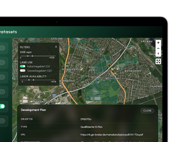
Land-Use (Flächennutzungsplan)
- Gewerbliche Baufläche (G)
- Other FNP classes where available
Zoning / Development (B-Plan)
- Gewerbegebiet (GE)
- Industriegebiet (GI)
- Additional B-Plan zones where published digitally
Motorway Proximity
- Identify areas with strong transport accessibility.
Labor Availability
- Assess population and employment indicators to understand regional labour context.
Parcels
- Filter parcels by size where parcel polygons are part of digitised B-Plan datasets.
Unified coverage across all 16 German federal states: Mapular aggregates planning, zoning, infrastructure and demographic datasets from every federal state. Because each state publishes data differently, coverage ranges from fully digitised GIS layers to partial coverage or document-based sources. All datasets are presented in one unified structure. Coverage expands continuously as new digital datasets and services are released by states and municipalities.
Fully digitised FNP and zoning datasets, ready for spatial analysis. All data is provided in a unified structure and can be fully filtered, queried and visualised within the explorer tool / accessed in the data set.
Planning and zoning information is partially available in digital form. All digital components are integrated into the explorer tool / data set; any missing areas are complemented with transparent links to official portals.
Planning information is only available as documents or through municipal portals. The explorer tool / data set provides direct access to these official sources, keeping all research centralised and easy to navigate.
An instant planning and mapping interface - No GIS setup required.
Align infrastructure investments with planning and zoning realities.
Accelerate feasibility studies, market assessments and location reports.
Compare zoning, land-use and demographic context across municipalities.
Identify GE/GI zones, evaluate transport access and assess workforce availability.
Locate suitable expansion areas by combining planning context, demographics and accessibility.
Identify spatial opportunities, development corridors and long-term planning trends.
Use harmonised multi-state data as structured inputs for analytical models.
No. We aggregate and present public datasets exactly as published. We apply a unified schema for consistency, but do not alter underlying content.
Each state publishes planning data differently. Some offer GIS layers, others documents or portals. We include all publicly available sources.
Yes. All data can be exported and integrated into your systems.
Weekly, aligned with newly published planning or zoning data.
No. It’s included for convenience, but the core product is the harmonised dataset.
To start, just schedule a call with our team.
Coverage improves as new GIS layers becomes available.
